In high-latitude regions, larger and more frequent fires have been documented over the last years, and it is expected to increase further due to warmer temperatures and decreased precipitation imposed by climate change (IPCC,2019). Boreal wildfires in general are a significant source of CO2 emissions, as well as other, greenhouse gases (Akagi et al. 2011; Van Der Werf et al. 2010), e.g. emissions from boreal forests between 1997 and 2016 accounted for 7.4% of the global emissions (van der Werf et al. 2017).
The effect of boreal fires on the future climate has not been investigated and is of great importance since climate change is occurring more rapidly in those high-latitude areas. More flammable forests in addition to the large carbon-rich peatlands, will potentially lead to devastating consequences for our climate.
In our project, the combination of satellite data and earth system models will create an innovative methodological framework for the study of wildfires. More precisely, we will first characterize the state of the atmosphere and climate based on past and present wildfire conditions. The future impact of wildfires will be investigated, employing modeling, observations and new analysis tools.
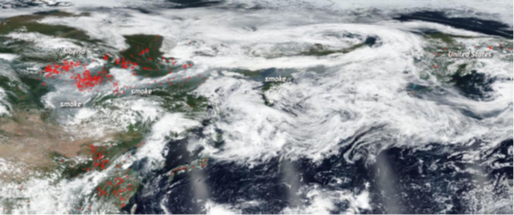
Figure 1. Hundreds of fires burning across Siberia on 30th July 2019, and the smoke produced heading towards North America (source: NASA). The summer of 2020 featured even more intense burning. https://www.nasa.gov/image-feature/goddard/2019/siberian-smoke-heading-towards-us-andcanada
References
- IPCC,2019: Jia, G., E. Shevliakova, P. Artaxo, N. De Noblet-Ducoudré, R. Houghton, J. House, K. Kitajima, C. Lennard, A. Popp, A. Sirin, R. Sukumar, L. Verchot, 2019: Land–climate interactions. In: Climate Change and Land: an IPCC special report on climate change, desertification, land degradation, sustainable land management, food security, and greenhouse gas fluxes in terrestrial ecosystems [P.R. Shukla, J. Skea, E. Calvo Buendia, V. Masson-Delmotte, H.-O. Pörtner, D.C. Roberts, P. Zhai, R. Slade, S. Connors, R. van Diemen, M. Ferrat, E. Haughey, S. Luz, S. Neogi, M. Pathak, J. Petzold, J. Portugal Pereira, P. Vyas, E. Huntley, K. Kissick, M, Belkacemi, J. Malley, (eds.)]. In press.
- Akagi, S.K. et al., 2011: Emission factors for open and domestic biomass burning for use in atmospheric models. Atmos. Chem. Phys., 11, 4039–4072, doi:10.5194/acp-11-4039-2011.
- Van Der Werf, G.R. et al., 2010: Global fire emissions and the contribution of deforestation, savanna, forest, agricultural, and peat fires (1997–2009). Atmos. Chem. Phys., 10, 11707–11735, doi:10.5194/acp-10-11707-2010.
- Van Der Werf, G.R. et al., 2010: Global fire emissions and the contribution of deforestation, savanna, forest, agricultural, and peat fires (1997–2009). Atmos. Chem. Phys., 10, 11707–11735, doi:10.5194/acp-10-11707-2010.