Twitter is increasingly being used as a real-time human-sensor network during natural disasters, detecting, tracking and documenting these events. Social media data represents a large amount of publicly available, unprocessed social data which is both opinionated, informative, and emotional. During disaster scenarios, users post a geographically and emotionally subjective account of events unfolding locally. There is scope for this information to be collated and analysed in real-time, and incorporated into wildfire models to improve their accuracy. 

This PhD project aims to help make disaster management teams make more informed, data driven decisions by including social media analysis as a data source in real-time wildfire models. In doing this, we aim to create more socially conscious wildfire models, which consider the impacts of wildfire spread.

Project duration: 2020-2024

Leadership Team

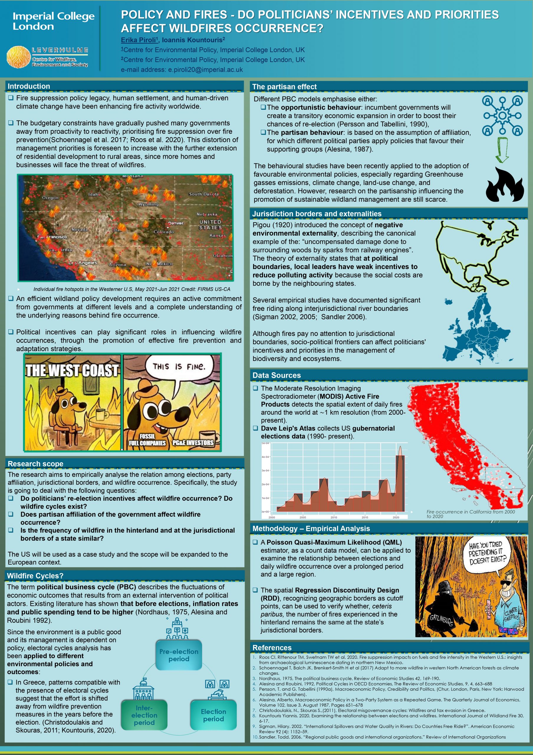
Fire suppression policy legacy, human settlement, and human-driven climate change have been enhancing fire activity worldwide. The budgetary constraints have gradually pushed many governments away from proactivity to reactivity, prioritising fire suppression over fire prevention (Schoennagel et al. 2017; Roos et al. 2020). This distortion of management priorities is foreseen to increase with the further extension of residential development to rural areas, since more homes and businesses will face the threat of wildfires. An efficient wildland policy development requires an active commitment from governments at different levels and a complete understanding of the underlying reasons behind fire occurrence. Political incentives can play significant roles in influencing wildfire occurrences, through the promotion of effective fire prevention and adaptation strategies.

Research Scope:

The research aims to empirically analyse the relation among elections, party affiliation, jurisdictional borders, and wildfire occurrence. Specifically, the study is going to deal with the following questions:

❑ Do politicians’ re-election incentives affect wildfire occurrence? Do wildfire cycles exist?

❑ Does partisan affiliation of the government affect wildfire occurrence?

❑ Is the frequency of wildfire in the hinterland and at the jurisdictional borders of a state similar?

The US will be used as a case study and the scope will be expanded to the European context.


Research Background:

  • Wildfire cycles?

The term political business cycle (PBC) describes the fluctuations of economic outcomes that results from an external intervention of political actors. Existing literature has shown that before elections, inflation rates and public spending tend to be higher (Nordhaus, 1975, Alesina and Roubini 1992). Since the environment is a public good and its management is dependent on policy, electoral cycles analysis has been applied to different environmental policies and outcomes: ❑ In Greece, patterns compatible with the presence of electoral cycles suggest that the effort is shifted away from wildfire prevention measures in the years before the election. (Christodoulakis and Skouras, 2011; Kountouris, 2020).

  • Partisan effect

Different PBC models emphasise either:

❑The opportunistic behaviour: incumbent governments will create a transitory economic expansion in order to boost their chances of re-election (Persson and Tabellini, 1990),

❑The partisan behaviour: is based on the assumption of affiliation, for which different political parties apply policies that favour their supporting groups (Alesina, 1987).

The behavioural studies have been recently applied to the adoption of favourable environmental policies, especially regarding Greenhouse gasses emissions, climate change, land-use change, and deforestation. However, research on the partisanship influencing the promotion of sustainable wildland management are still scarce.

  • Jurisdiction borders and externalities

Pigou (1920) introduced the concept of negative environmental externality, describing the canonical example of the: “uncompensated damage done to surrounding woods by sparks from railway engines”. The theory of externality states that at political boundaries, local leaders have weak incentives to reduce polluting activity because the social costs are borne by the neighbouring states. Several empirical studies have documented significant free riding along interjurisdictional river boundaries (Sigman 2002, 2005; Sandler 2006). Although fires pay no attention to jurisdictional boundaries, socio-political frontiers can affect politicians’ incentives and priorities in the management of biodiversity and ecosystems.

Project duration: 2020-2024

Download poster


Leadership Team

Wildfire frequency and intensity is in turn increasing the wildfire exposure of embers, radiative heat and flames on the built environment. Residential areas adjacent to or intermixed with the wildlands, referred to as the wildland-urban interface (WUI), face high risk and regularly experience devastating losses; recent tragic Southern European WUI fire examples include the 2017 Pedrógão Grande Fire Complex in Portugal and 2018 Attica wildfires in Greece. Successfully preventing building ignitions by improving building fire resistance, can eliminate WUI disasters despite increasing wildfire exposures. Embers are often cited as the leading cause of wildfire building damage and destruction; however, detailed understanding of ember accumulation and ignition dynamics and accurate simulations of ember exposure need further development. This project investigates Southern European WUI building damage due to wildfire, with the objective of providing practical recommendations to increase buildings’ resilience. By defining the most significant Southern European building construction components and wildfire exposures, relevant mitigation strategies are tested computationally and experimentally. This research focuses on common local WUI building construction materials and assemblies, ember accumulation and ignition, and building ignition mitigation methods.

Simona is based at Imperial College London, supervised Prof. Guillermo Rein; the research is part of the PyroLife ITN project funded by the European Union Horizon2020 project and collaborates with ITB Poland and NFPA.


Figure: Diagram of wildfire threat approaching WUI home with labelled vulnerable building components, Simona Dossi 2021

Leadership Team

This PhD aims to examine how behavioural modelling may provide the basis for improved representations of anthropogenic fire impacts in global-scale process-based models. It does this by quantifying the influence of human behaviour on wildfire regimes around the world and developing agent-based representations of that influence to integrate with the existing JULES-INFERNO model.


A central finding of the Fire Model Intercomparison project (FIREMIP) was that simple representations of anthropogenic impacts on fire – based on readily available data such as population density or GDP – are a substantial shortcoming in current global fire models.

This shortcoming stems from two key research challenges:

1. the absence of a systematic empirical basis from which to derive improved representations of people in global models.

2. the lack of appropriate modelling frameworks through which to capture and project anthropogenic fire impacts globally.

This project aims to address both these research challenges.

To address the first research challenge, we have developed DAFI: the first global Database of Anthropogenic Fire Impacts. DAFI currently contains data from over 500 papers on more than 1,800 case studies from 100 countries between 1990-2020. DAFI is freely available to download and you can read more about it on this poster (peer-reviewed publication forthcoming).


We presented progress on the second research challenge at EGU 2021 in our presentation entitled, Advancing representation of anthropogenic fire in dynamic global vegetation models. You can download the slides [pdf] accompanying the presentation, or view them online.

Project duration: 2020-2024

Leadership Team

This project aims to quantify the damages from wildfires using economic valuation methods, specifically stated preference valuation methods focussing on rural and urban/peri-urban environments in the European Mediterranean. It also aims to improve the understanding of the human-wildfire relationship by analysing the effects of wildfires on human wellbeing. In turn, the thesis will produce outputs that allow scientists and policymakers to better understand the relationship between wildfires and society.

The objectives of this thesis are as follows:

1.Identify the impacts wildfires have on humans

a) Undertake a review of the impacts of wildfires on ecosystem services, recreation and human health.

b) How these impacts relate to individuals’ risk perception

c) What valuation methods are used to assess them.

2. Contribute to the evidence base by assessing wildfire impacts on rural populations using stated preference valuation techniques.

a) Undertake extensive interviews with relevant stakeholders and researchers around the island to better understand wildfires in Crete

b) Design and implement a choice experiment to estimate cost of damages of wildfires. The choice experiment will understand people’s preferences to support a wildfire mitigation programme on the island. Specifically, the proposed programme addresses and implement the following issues identified in Crete and will be part of the: to reduce the risk of wildfire, risk of post-wildfire damages, loss of agriculture and implement hard engineering to maintaining the cultural and traditional landscape of Crete. Overall, this choice experiment will determine the damages associated with wildfires. Furthermore, this objective also complements objective 1 as it identifies and evaluates the impact of wildfires on humans.

3. Contribute to the evidence base by assessing wildfire impacts on Urban/peri-urban populations using stated preference valuation techniques. This is yet to be implemented but will be in another urban location within the European Mediterranean, possibly still in Greece.

H. Misal POSTER – A Q-methodology approach to understanding causes and drivers of wildfires in Crete, Greece

H Misal – POSTER – Assessing public preferences for wildfire mitigation policy in Crete, Greece


Leadership Team

Wildfires and other forms of landscape burning are complex, dynamic and in some ways difficult to predict and certainly potentially dangerous phenomena. Fires up to even extreme mega-fire events can be studied using the techniques of remote sensing and modelling, but these studies and those of smaller burns often need to be informed by and sometimes combined with data from in situ investigations, for example on the spectral properties of the fires if using remote sensing and on the different composition of their smoke and what controls that if estimating emissions. This in situ data can be collected in the field on planned burns or even on wildfires were possible, and can also be supplemented – where appropriate – by data collected in laboratory fires under more controlled conditions. The purpose of this technical postdoctoral project is to deliver the capability to make and analyse these measurements to support specific aspects of the Centre’s work on fire spectral signatures and smoke emissions, as well as wider investigations.

Project duration: 2019- ongoing

Leadership Team

Wildfires and other forms of landscape burning turn solid material held in vegetation and organic soil into a complex mix of airborne gases and particulates. When conducted over large areas and/or in extreme fires, this rapid process can result in massive atmospheric impacts, perhaps most particularly on air quality (AQ). Landscape fires of this sort are thus responsible for severe AQ episodes, including some of the world’s worst events that likely impact the health of millions. Furthermore, in many regions of the developing world recurrent burning of agricultural waste over huge areas of croplands leads to air pollution episodes that routinely affect the air that hundreds of millions of people breath, including in some of the largest mega-cities on Earth. However, it can be hard to disentangle the contribution landscape fires make to the poor air quality of these areas because many of the areas affected suffer from a paucity of in situ atmospheric measurements for example. Regional AQ modelling can deploy state-of-the-art information on different emissions sources, including landscape fires and agricultural burning, to address these and other related questions, ultimately informing studies of human health and also potentially agricultural policy development related to changing patterns and timing of cropping. Other uses of such modelling include the study of the radiative effects of the short-lived climate impactors (SLCPs) and to support the evaluation and validation of new fire emissions estimates coming from Earth Observation – which are extremely difficult to validate directly or through other means but which when placed within a regional AQ model can provide metrics such as aerosol optical depth timeseries that can be compared to high accuracy in situ data.

Project duration: 2021-2025

Leadership Team

Partners