
Welcome to the first Giraffe Team Bulletin!
For those new to our “Giraffe Teams”, you can find out more about each one of them, including their overall aims and objectives, here. Our giraffe teams are bit like ‘tiger teams’ (a term used in business) with specialists working together to tackle specific problems, but we are sticking our necks out with lofty ambitions – a bit like giraffes (!)… and so, our ‘Giraffe Teams’ were formed!
Approximately every two months, we will be sharing a Giraffe Team bulletin, providing you with an update on the latest from each of our six teams. We hope you enjoy the bulletins and that it helps you keep abreast of our research. Please do get in touch if you want to find out more about anything in the bulletin (either wildfire@imperial.ac.uk or contact the researchers involved).
Just Fire Giraffe Team
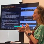
Several members of the Just Fire Giraffe Team recently convened and contributed a session at the Royal Geographical Society Annual Meeting.
James Millington and Kapil Yadav convened the session with Christoph Neger of the National Autonomous University of Mexico. Abi Croker, Henry Thompson, Michele Valette and James Millington gave oral presentations on their and colleagues work ongoing in the Centre:
- Abi presented her Bayesian Network model for African savanna protected areas
- Henry and Michele presented on their fieldwork in Ethiopia and Brazil
- James presented the recent global-level data and modelling work that Ol Perkins and Cathy Smith have led on over the last few years.
After the talks presenters and audience had an interesting discussion on whose maps count, including methodological issues of mapping human fire and variation in fire management and fire use practices around the world.
Thanks to Jay Mistry for the photos from the session, which was joined by one of our newest (and the cutest) team members – Felix!
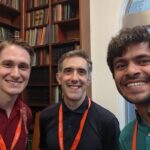
Photos – RGS conference (click on the image for full size)
We continue to make progress publishing and developing WHAM!, the Wildfire Human Agency Model. We have just received reviews on the manuscript about the WHAM-INFERNO coupled model we submitted to Earth’s Future in April 2024 and are now addressing these. Over the summer Ol has been working to downscale the WHAM model to 0.25 degrees (from INFERNO resolution – 1.875° × 1.25°;) and incorporated additional land system processes, specifically application of nitrogen fertiliser and grazing pressure which relate to amount and timing of burning.
Fire-Veg Giraffe Team
The Fire-Veg Giraffe Team has just had a literature review on the global drivers of burnt area accepted in Frontiers (Frontiers | The global drivers of wildfire (frontiersin.org). This review showed that factors relating to fuel loads and fuel drying were emerging as the most important for understanding the patterns of burnt area globally. We have also been refitting the General Linear Models (GLMs) on a longer-time frame (2001 to 2021) and with updated products and trying to mask out cropland fires to test the robustness of the relationships between burnt area, fire size and fire intensity to climate, vegetation, human and topography. We are also exploring how leaf traits may be important in explaining the patterns of vegetation flammability, something we are hoping will improve our understanding of what controls fire intensity and occurrence. Finally, we are moving from empirical analysis to developing theory. We are focusing on a theory for fuel loads as well as for flammability. We are exploring the idea that by focusing on the seasonal cycles of productivity and atmospheric dryness we can identify regions and periods of high flammability.
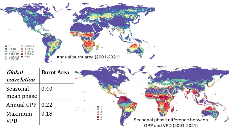
Figure: Exploring the global correlation between burnt area and the difference in the seasonal maximum of productivity (GPP) and atmospheric humidity (VPD).
Climate Giraffe Team
The Climate Giraffe Team is a collaboration between researchers primarily in the Department of Physics at Imperial College, Imperial HazeLab, and the Technical University of Crete (TUC). It focuses its efforts on answering questions related to the two-way connection between wildfires and climate. It’s a two-way connection because wildfires are influenced by meteorological conditions and climate change, while also they affect atmospheric conditions and therefore climate through the emissions that they produce.
When it comes to the impacts of wildfires on the atmosphere, there is a range of activities within the Climate Team that examine how specific fire events as well as longer-term wildfire changes modify atmospheric composition, air quality, meteorological conditions, and climate. Particular focus has been placed recently on a) how aerosols and gases emitted from fires affect the pre-industrial to present-day and future radiative forcing of climate, and b) how extreme wildfire events can impact the global and regional atmosphere in the short term.
In recent, state-of-the-art modelling experiments (Iulian-Alin Rosu from TUC and Matt Kasoar from ICL Physics), we are finding that e.g. the Canadian wildfires of 2023 have likely affected temperatures drastically across the Northern Hemisphere for months via aerosol-induced cooling, also potentially causing hydrological effects in areas as far as South Asia and its monsoon system.
When it comes to climate influences on wildfires (the other side of the wildfire-climate connection), our efforts focus on two areas: a) improving peat fire representation in Earth system models and understanding how climate change might affect the future of boreal peat burning and emissions, and b) improving the equations that link meteorological and climate variables with burnt area and emissions, for use in fire risk assessment and fire modelling.
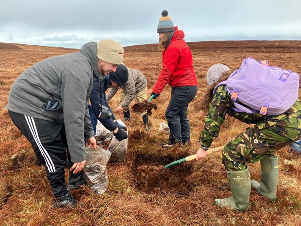
Photo: collecting peat for experimental burns
A major activity currently ongoing is the study of peat combustion in the lab (Dimitra Tarasi from TUC in collaboration with the Haze Lab), using both commercial peat samples and samples collected in the field by our Team (Winterfell II Field Trip). The new findings will inform novel approaches for modelling peat fires and emissions in global fire models and Earth system models, building also on the recent pioneering work of Katie Blackford (ICL Physics) on introducing a peat fire module for the JULES-INFERNO global fire model.
This is part of a broader array of efforts conducted through our collaborations with the Met Office (Chantelle Burton) and with KCL (James Millington and Ol Perkins) with the purpose to further advance the capabilities of JULES-INFERNO – the first and main tool used by the UK Earth system science community for fire modelling.
Air Quality Giraffe Team
The Air Quality Giraffe Team have been continuing analysis of the SE Asia sensor network following the 2024 fire season and are comparing this data to the CAMS models. The current challenge is trying to understand reasons for discrepancies in the sensor-model comparisons (whether due to spatial variability/resolution, incorrect emissions assumptions, or something else). We are also investigating improved sensors to use on UAVs in smoke plumes to capture a wider range of gas emissions and will soon be trailing a new commercial system. This will enhance our previous work on quantifying fire emissions from a UAV in Laos.
Researchers from the AQ G-Team, together with wider members of the King’s EO team have been busy preparing for a field campaign in Alberta, Canada (campaign is funded by ESA). Some of this will expand the work undertaken last year using thermal cameras to validate satellite measurements of fire characteristics after promising initial results, but this year is expanded to include improved in-situ instruments on the plane (multiple gases, particulates, trace chemical compounds eg PAHs) and also flying our ‘HyperCam’ imaging spectrometer over fires for the first time. Theoretically, this can map elevated methane (and certain other gases) from a plume but so far we have only been able to test this in the combustion chamber.
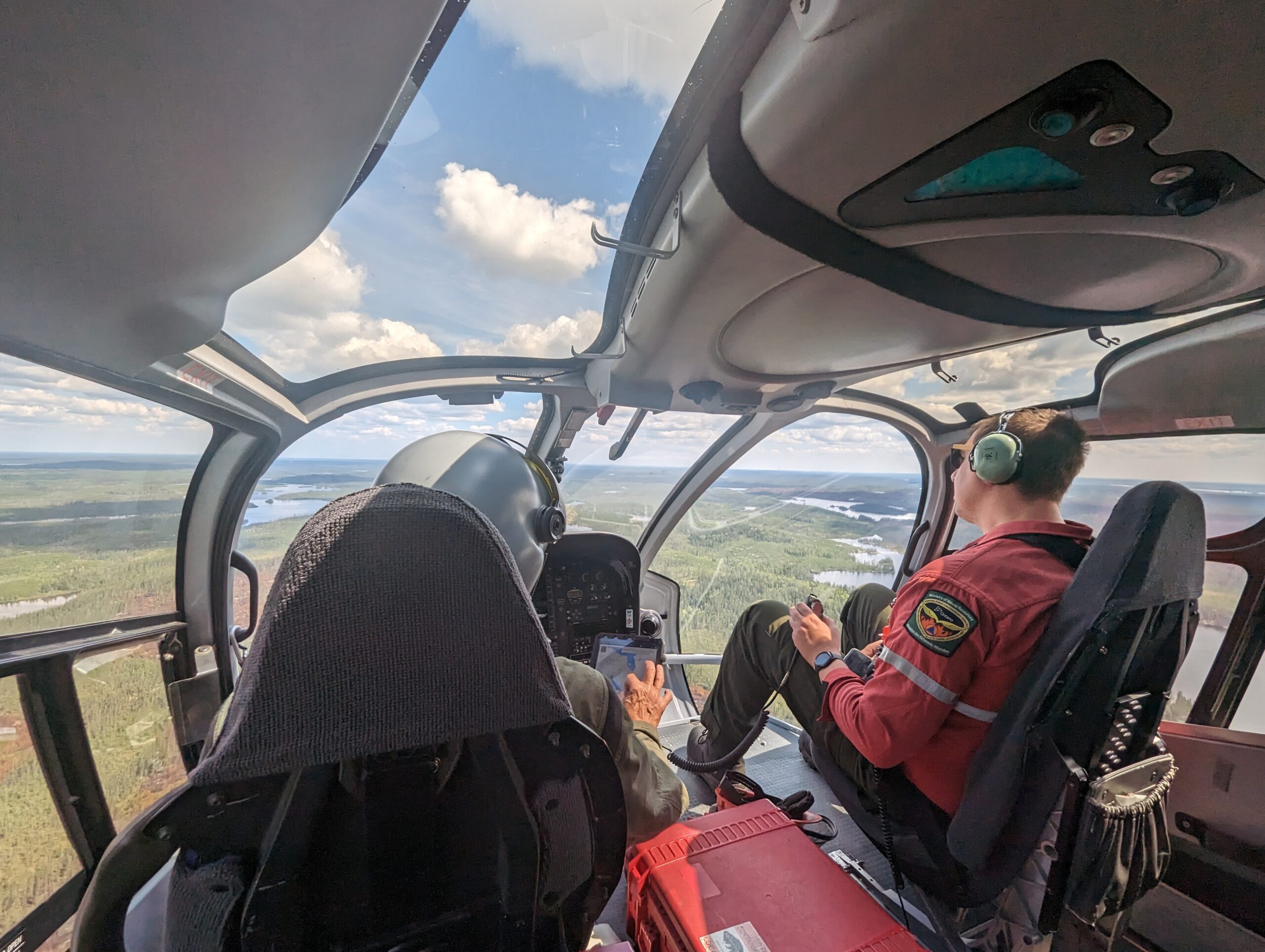
Photo: Fieldwork in Ontario, Canada, in 2023. We are currently preparing for the 2024 campaign.
Fire Info Giraffe Team
Most activities within the Fire Info Giraffe Team are focused on estimating emissions using satellite data. This is a critical activity, as current estimates from e.g. GFED or similar databases are based on a long list of assumptions. EO methods such as the ones being explored by the team here would provide independent estimates that would allow us to challenge some of the modelling assumptions embedded in products such as GFED.
We are currently enhancing and generalising methods to link fire radiative power (FRP) estimates with excess carbon monoxide (CO) (and aerosol optical depth, AOD) concentrations within plumes. The goal is to develop models that can predict excess CO from FRP. At present, this process involves manually collecting plume and FRP data, which is time-consuming and limits the number of samples available for building robust models. To address this, Zitong Li is experimenting with machine learning techniques to automate plume detection, which will significantly increase our ability to develop more reliable models.
Similarly, while the relationship between FRP and excess CO (or AOD) appears to be quite robust, there remains a considerable amount of variability. We have managed this by differentiating the relationships across various biomes and by localising models to specific regions. However, it would be highly beneficial to extend these models to include additional covariates, such as fuel moisture and canopy openness, to improve accuracy and potentially reduce the need for biome-specific models.
We are also making advancements with new geostationary satellite technologies. Weidong Xu is working on the official thermal anomalies and FRP products for the Meteosat Third Generation (MTG) satellites, which represent a substantial improvement over the Meteosat Second Generation. MTG offers higher spatial resolution and the capability to detect smaller fires every 10 minutes. This improvement is illustrated in the figure below, which compares FRP data from both sensors and demonstrates MTG’s enhanced ability to resolve more fires, especially the smaller, less energetic ones that occur at night.
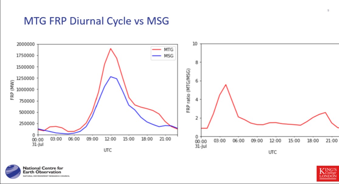
Figure: comparison of FRP data from both sensors and demonstrates MTG’s enhanced ability to resolve more fires, especially the smaller, less energetic ones that occur at night
The animations below show the evolution of the recent fires near Athens from MTG (Meteosat Third Generation) geostationary satellite. The temporal sampling is 10minutes. The frequent sampling and enhanced spatial and radiometric resolution results in more early fire detection over Africa and Europe. Importantly, this will greatly enhance our ability to track FRP over time for this region.
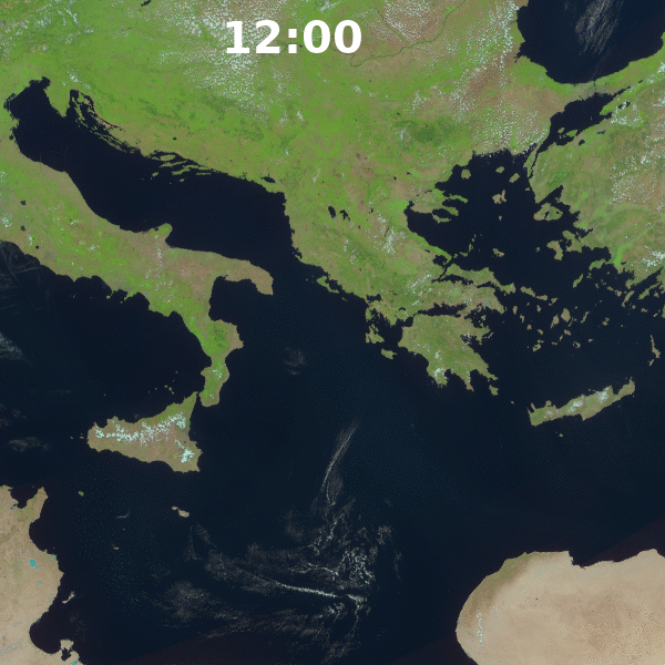
Gif by Weidong Xu, KCL
Video: Eumetsat showing a time lapse of all the acquisitions over a day of the recent fires close to Athens.
WIR3 Giraffe Team
Under the new ‘giraffe’ team structure, the WIR3 Team- which stands for Wildfire Insurance Risk, Regulation and Recovery – is about to start advertising and recruiting for three PhD studentships at Imperial and KCL on:
- Public experience of post-fire recovery (Imperial-CEP)
- Insurability and insurance market dynamics (KCL-Geography)
- Public acceptability of controlled burning to manage fuel at the wildland-urban interface (KCL-geography)
These new posts are in addition to the recently advertised studentship in KCL Engineering, on ‘Ignition and fire spread processes in the Wildland Urban Interface’ which will be undertaken by our new student Abdullah Rehman. There are two incredibly exciting developments for this project’s supervisor, Francesco Restuccia, who runs the KCL Heat and Fire Lab:
- The birth of his first child!
- An ERC Starting Grant Award for FIREMOD: Wildfires and Climate Change: Physics-Based Modelling of Fire Spread in a Changing World, which will fund a research team working across several Centre Giraffe teams
Several other pre-existing projects aligned with the WIR3 team continue to make good progress. KCL postdoc, Max Stiefel presented some preliminary findings from his project on ‘Classifying Wildfire Protection Strategies in Community Wildfire Protection Plans with Natural Language Processing’ at the Association of American Geographers Conference in April. Max is continuing to refine his model and data work flow and starting to collaborate with David Demeritt in trying to interpret the correlation matrix for characteristics of >1000 wildfire protection plans in 11 states of the Western United States.
Angel Goldsmith, a PhD student at KCL, has now completed the fieldwork for his PhD on wildfire management at the wildland-urban interface in South Africa. In addition to working on his first paper for publication based on a presentation he did last October for the Working on Fire 20th Anniversary Fire Symposium in Kruger National Park, South Africa, he is also preparing a presentation this November on ‘Social Capital and Organizational Capacity as Pathways for Fire Risk Education in Wildland-Urban Interface for Nelson Mandela University’s 14th Fire Management Symposium on the theme of ‘Educating and training for effective wildfire management’.
September 2024
Thank you to all the Giraffe Team leads for providing the updates.
