
by Kalin Pugh, Royal Holloway – reporting on their undergraduate research placement with Leverhulme Wildfires
Fires, Farming and Policy in Ireland
At the end of July, I went to West Cork, Ireland, to conduct contextual fieldwork as part of my preparation for writing my undergraduate dissertation during a placement between Royal Holloway, University of London, and the Leverhulme Wildfires Centre. My dissertation is on ‘Spatiotemporal analysis of upland fires in SW Ireland: testing the impact of the Common Agricultural Policy on upland land management’. This involves three main areas of research: (1) the spatiotemporal analysis of fires using satellite data; (2) examining sociopolitical changes around agriculture in Cork and Kerry and (3) looking for connections between sociopolitical changes and fire patterns. My fieldwork was supervised by Dr Will Hayes, from Leverhulme Wildfires (RHUL), who is conducting a wider body of research on relationships between farming and fire usage in South-West Ireland.
Burning is a land management practice that has been used in Ireland for centuries: it involves setting fire to areas of land, normally uplands used for grazing, to clear foliage and shrubbery which sheep or cattle refuse to eat. Environmental protection laws in recent decades have put limits on when these fires can be set in order to protect ground-nesting birds and reduce the risk of wildfires starting from a planned burn. Changes to subsidy payments from the Common Agricultural Policy run by the EU have impacted the way farmers use upland areas and consequently, if they are using fire as a management technique. My project is trying to map satellite evidence to look for changes in when and where the fires occur, and whether they can be linked to the Common Agricultural Policy payment shifts.
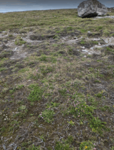
Image: Post-fire landscape
Fieldwork in West Cork
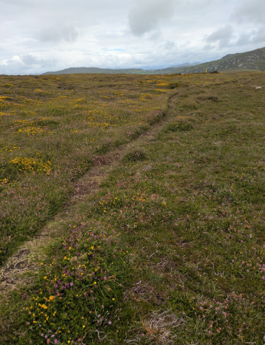
As part of my trip to Ireland, I saw post-fire landscapes at the Béal na Carraige peninsula in County Cork. Planned burns had taken place in patches across the peninsula a few years beforehand and the vegetation was in various states of recovery across the patches. Some had very little recovery but in others, gorse and heather were beginning to return. The scorched earth clearly marked where the fires had taken place and fire breaks had been cut to stop the fires spreading outside of the planned areas. Across the wider peninsula, there hadn’t been recent burning but there had likely been fires further in the past, suggested by patches of vegetation of varied height.
Farming in the uplands of South-West Ireland, like many agricultural areas across Europe, has faced significant socioeconomic challenges and climate change related issues over the 21st century. Sheep are the most common livestock kept in the area- there are more financial incentives to keep sheep than there are to keep cattle and they also require less intensive handling. Sheep are pickier eaters than cattle are when grazing and this means they ignore some plants that happen to be particularly flammable- such as bracken and Molinia caerulea, a type of grass often found on the uplands that overtakes every other species and can grow to over a metre tall. On my trip, I saw and walked through large areas of hillside covered in the Molinia caerulea- it’s an incredibly dangerous fuel for any wildfires that break out. Part of my dissertation will look at spotting any links between introduction of the agricultural subsidies that encourage keeping sheep, overgrowth of Molinia caerulea and increases in size or frequency of upland fires in the overgrown areas.
Reflections and Next Steps
My trip was a brilliant experience. I learned so much about conducting fieldwork, research using both quantitative and qualitative approaches, and exploring the intersections between issues affecting people and the natural world that wouldn’t necessarily be automatically connected. It has also provided a fantastic background for me to research and write my dissertation against. I would like to extend my biggest thanks to the Leverhulme Centre for Wildfires, Environment and Society for funding and supporting the trip, as well as allowing my placement, and Dr Will Hayes for his guidance on the fieldwork and my dissertation.
About Kalin Pugh
“By day, I’m a third-year undergraduate student at Royal Holloway, University of London, studying Geography, Environment and Climate. I’m interested in intersectional geography- I like studying the connections between physical and human geography topics and how both sectors can work together to solve problems for everyone. By night, I teach Latin, French and Geography- where I mention wildfires in every possible lesson!”
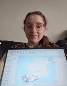
Photo left: Kalin Pugh with of their fire maps for this project
Cover image: Fire break, Cork
