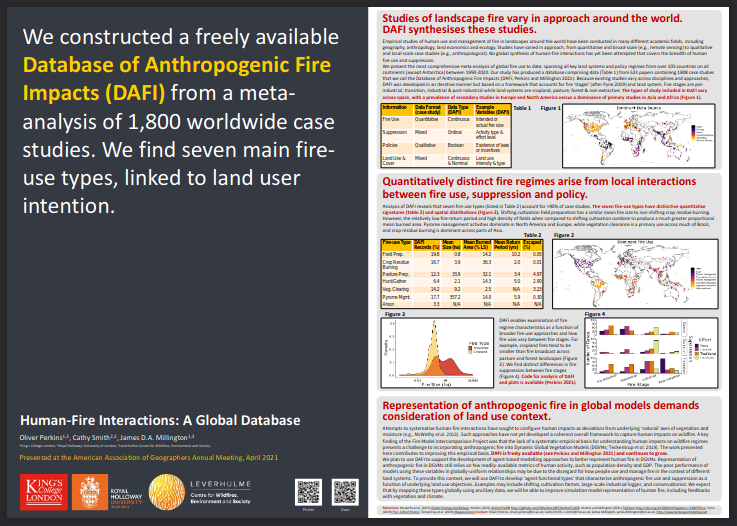
Recent studies have shown that temperature and precipitation in the Mediterranean are expected to change, indicating longer and more intense summer droughts that even extend out of season. In connection to this, the frequency of forest fire occurrence and intensity will likely increase.

This PhD project is therefore assessing the changes in future fire danger conditions for the different regions of Greece using the Canadian Fire Weather Index (FWI), utilizing gridded future climate outputs, estimated from six regional climate models from the Coordinated Regional Downscaling Experiment (CORDEX).

The study uses three Representative Concentration Pathways (RCPs) consisting of:

  1. an optimistic emissions scenario where emissions peak and decline beyond 2020 (RCP2.6);
  2. a mid-of-the-road scenario (RCP4.5);
  3. and a pessimistic scenario, in terms of mitigation, where emissions continue to rise throughout the century (RCP8.5).

The FWI projections were assessed for two future time periods, 2021-2050 and 2071-2100, comparing to a reference time period in the recent past 1971-2000. Based on established critical fire risk threshold values for Greece, the future change in days with critical fire risk were calculated for different Greek domains.

The results show that future fire danger is expected to progressively increase in the future, especially in the high-end climate change scenario, with southern and eastern regions of Greece exhibiting increases in the FWI that exceed 20 FWI units, on average.

Furthermore, southern Crete, the Aegean Islands, the Attica region, as well as parts of eastern and southern Peloponnese are predicted to experience a larger increase in the fire danger, with an additional 12-17 potential fire days in the distant future (2070-2100) when compared to the reference period, under the RCP8.5 scenario.

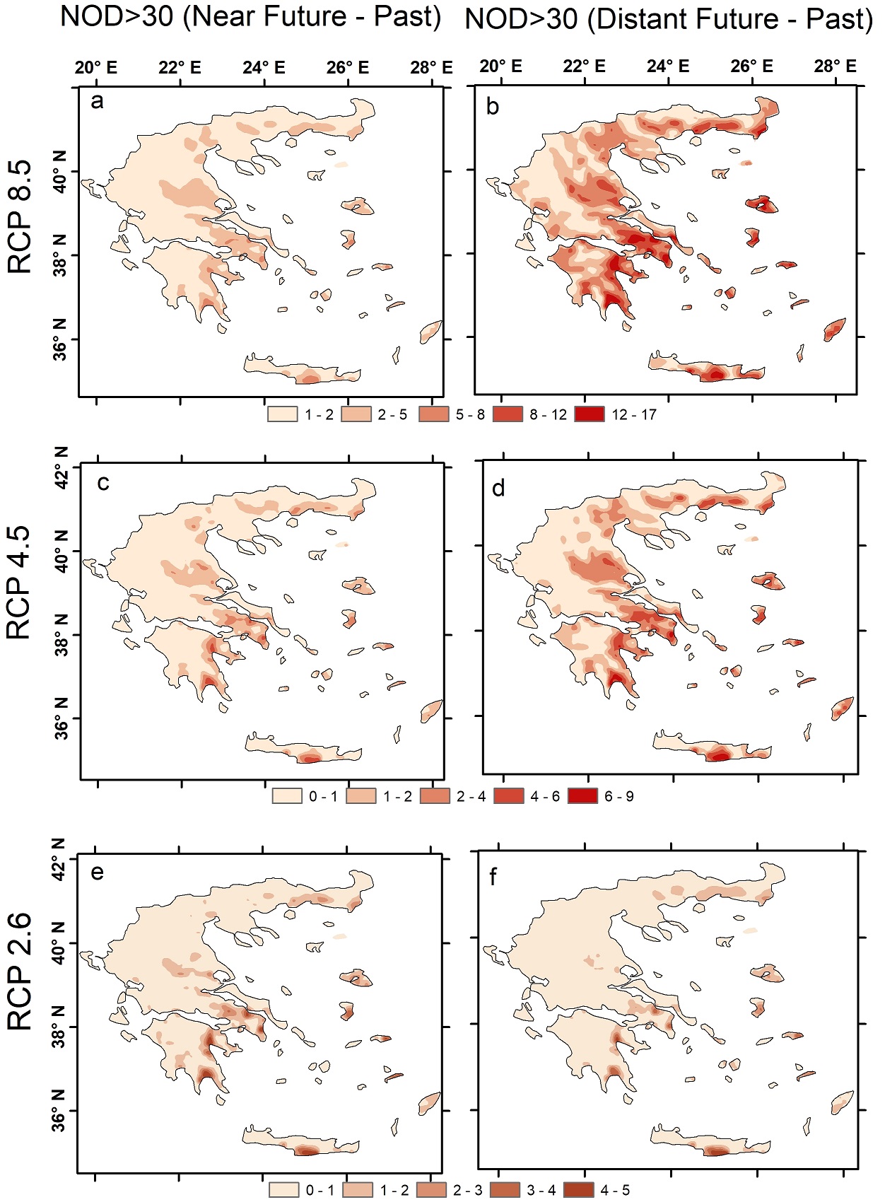
Figure: Difference in the annual ensemble mean number of days (NOD) with FWI>30 between the future periods (for all future scenarios) and the reference period. The left column corresponds to the difference for the near future period [(2020-2050) – (1970-2000)] and the right column to the difference for the distant future [(2070-2100) – (1970-2000)].

Also involved in the study: Christos Giannakopoulos and Anna Karali from the Institute for Environmental Research and Sustainable Development, National Observatory of Athens; Robert Field from the Department of Applied Physics and Applied Mathematics, Columbia University; and Mihalis Lazaridis and Kostadinos Seiradakis from the School of Environmental Engineering, Technical University of Crete.


Cover image: Varnavas, Greece, 2009, by Filippos Sdralias


Leadership Team

This PhD aims to examine how behavioural modelling may provide the basis for improved representations of anthropogenic fire impacts in global-scale process-based models. It does this by quantifying the influence of human behaviour on wildfire regimes around the world and developing agent-based representations of that influence to integrate with the existing JULES-INFERNO model.


A central finding of the Fire Model Intercomparison project (FIREMIP) was that simple representations of anthropogenic impacts on fire – based on readily available data such as population density or GDP – are a substantial shortcoming in current global fire models.

This shortcoming stems from two key research challenges:

1. the absence of a systematic empirical basis from which to derive improved representations of people in global models.

2. the lack of appropriate modelling frameworks through which to capture and project anthropogenic fire impacts globally.

This project aims to address both these research challenges.

To address the first research challenge, we have developed DAFI: the first global Database of Anthropogenic Fire Impacts. DAFI currently contains data from over 500 papers on more than 1,800 case studies from 100 countries between 1990-2020. DAFI is freely available to download and you can read more about it on this poster (peer-reviewed publication forthcoming).


We presented progress on the second research challenge at EGU 2021 in our presentation entitled, Advancing representation of anthropogenic fire in dynamic global vegetation models. You can download the slides [pdf] accompanying the presentation, or view them online.

Project duration: 2020-2024

Leadership Team

This project aims to quantify the damages from wildfires using economic valuation methods, specifically stated preference valuation methods focussing on rural and urban/peri-urban environments in the European Mediterranean. It also aims to improve the understanding of the human-wildfire relationship by analysing the effects of wildfires on human wellbeing. In turn, the thesis will produce outputs that allow scientists and policymakers to better understand the relationship between wildfires and society.

The objectives of this thesis are as follows:

1.Identify the impacts wildfires have on humans

a) Undertake a review of the impacts of wildfires on ecosystem services, recreation and human health.

b) How these impacts relate to individuals’ risk perception

c) What valuation methods are used to assess them.

2. Contribute to the evidence base by assessing wildfire impacts on rural populations using stated preference valuation techniques.

a) Undertake extensive interviews with relevant stakeholders and researchers around the island to better understand wildfires in Crete

b) Design and implement a choice experiment to estimate cost of damages of wildfires. The choice experiment will understand people’s preferences to support a wildfire mitigation programme on the island. Specifically, the proposed programme addresses and implement the following issues identified in Crete and will be part of the: to reduce the risk of wildfire, risk of post-wildfire damages, loss of agriculture and implement hard engineering to maintaining the cultural and traditional landscape of Crete. Overall, this choice experiment will determine the damages associated with wildfires. Furthermore, this objective also complements objective 1 as it identifies and evaluates the impact of wildfires on humans.

3. Contribute to the evidence base by assessing wildfire impacts on Urban/peri-urban populations using stated preference valuation techniques. This is yet to be implemented but will be in another urban location within the European Mediterranean, possibly still in Greece.

H. Misal POSTER – A Q-methodology approach to understanding causes and drivers of wildfires in Crete, Greece

H Misal – POSTER – Assessing public preferences for wildfire mitigation policy in Crete, Greece


Leadership Team

Wildfires and other forms of landscape burning turn solid material held in vegetation and organic soil into a complex mix of airborne gases and particulates. When conducted over large areas and/or in extreme fires, this rapid process can result in massive atmospheric impacts, perhaps most particularly on air quality (AQ). Landscape fires of this sort are thus responsible for severe AQ episodes, including some of the world’s worst events that likely impact the health of millions. Furthermore, in many regions of the developing world recurrent burning of agricultural waste over huge areas of croplands leads to air pollution episodes that routinely affect the air that hundreds of millions of people breath, including in some of the largest mega-cities on Earth. However, it can be hard to disentangle the contribution landscape fires make to the poor air quality of these areas because many of the areas affected suffer from a paucity of in situ atmospheric measurements for example. Regional AQ modelling can deploy state-of-the-art information on different emissions sources, including landscape fires and agricultural burning, to address these and other related questions, ultimately informing studies of human health and also potentially agricultural policy development related to changing patterns and timing of cropping. Other uses of such modelling include the study of the radiative effects of the short-lived climate impactors (SLCPs) and to support the evaluation and validation of new fire emissions estimates coming from Earth Observation – which are extremely difficult to validate directly or through other means but which when placed within a regional AQ model can provide metrics such as aerosol optical depth timeseries that can be compared to high accuracy in situ data.

Project duration: 2021-2025

Leadership Team

Partners