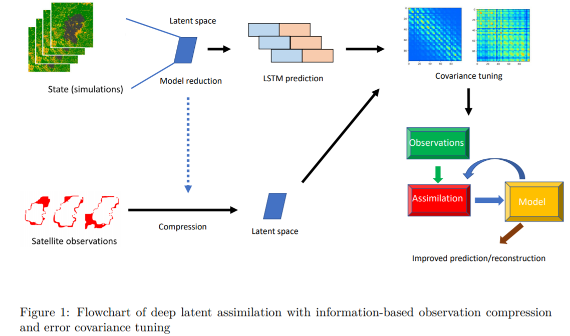
Real-time forecasting of wildfire dynamics which raises increasing attention recently in fire safety science world-widely, is extremely challenging due to the complexities of the physical models and the geographical features. Running physics-based simulations for large-scale wildfires can be computationally difficult, if not infeasible. In this work, we propose a novel algorithm scheme, which combines reduced-order modelling (ROM), recurrent neural networks (RNN), data assimilation (DA) and error covariance tuning for real-time forecasting/monitoring of the burned area. In this work, we make use of an operating cellular automata (CA) simulator to generate a dataset used to train a data-driven surrogate model for forecasting fire diffusions. More precisely, based on snapshots of fire diffusion simulations, we first construct a low-dimensional latent space via proper orthogonal decomposition (POD) or convolution autoencoder (CAE). A long-short-term-memory (LSTM) neural network is then used to build sequence-to-sequence predictions following the simulation results projected/encoded in the latent space. In order to adjust the prediction of burned areas, satellite data is assimilated in the data-driven surrogate model. A latent DA coupled with an error covariance tuning algorithm is performed with the help of daily observed satellite wildfire images as observation data. Thanks to ROM, the computational complexity of DA is also considerably reduced.

The framework currently proposed in this study can be easily applied to other spatial-temporal dynamics such as air pollution monitoring or environmental epidemiology. Future work can be considered to, for instance, extend the current approach to 3D systems with unstructured meshes or inhomogeneous time steps.

Leadership Team

This is an advanced data analysis project, requiring extensive hands-on experience with Earth Observation (EO) data from multiple platforms and well-developed IT skills. The project will deploy novel methods to jointly analyse different kinds of EO data (including fire attributes, vegetation and landscape properties, and indicators of settlement patterns) with the goal of developing a top-down global classification of fire regimes.

Image: Nayane Prestes, UNEMAT-Brazil, measures seedlings in a burned forest in Mato Grosso, southern Amazonia (photo credit: Ted R. Feldpausch)

Leadership Team

The focus of this project is to interact with all project scientists in order to continuously develop and advance our capabilities in global wildfire modelling and its integration into Earth system models. The tasks will involve a) Algorithm development based on quantitative and qualitative insight from individual projects in different strands; b) Model evaluation and benchmarking; c) Integration into the UK Earth System Model (UKESM) and subsequent evaluation of performance of atmospheric composition, vegetation, and related systems. 


Project duration: 2020 – ongoing

Leadership Team

Landscape fire burns across, on average, more than 3.5 million km2 of Earth’s surface every year, equivalent to roughly the entire area of India. This measure has been obtained using long-term satellite (EO) records, there is no other way to provide such information globally using a consistent and standardised measurement approach, but it is almost certainly an underestimate because of the relative spatial coarseness of the data used, which is unable to detected the smallest, but often most frequent, types of burn. The measure is also highly variable, with some areas seeing order-of-magnitude variations in burned area between years. This one example of the use of satellite remote sensing shows how use of EO is both essential when studying landscape fires over large scales, but also is not yet providing the full set of information. Other EO approaches such as the detection and quantification of actively burning fires and their thermal energy and smoke emissions provide complementary information, even in real time as the fires are still burning.

The purpose of this postdoctoral project is to provide an underlying EO capability for the Centre, pursuing efforts to improve and enhance EO methods to more accurately and precisely target landscape fire activity, synergistically combining EO and other datasets to provide new and/or more accurate insights into landscape fire properties and behaviours, and where appropriate aiding other Centre projects and activities to exploit the most appropriate EO techniques and datasets for their purposes  whilst being mindful of both the information content and its limitations. Overall this post is aimed at equipping the Centre to best exploit remote sensing and satellite EO methods when addressing its research goals.

Project duration: to start 2021

Leadership Team

This PhD project aims to devise a simplified, generic version of the fire-spread algorithm used operationally by the US and other fire services, and embedded in several global fire models (Rothermel’s ROS).

In the first stage, we aim to gather and harmonize data from wind tunnel experiments and remote sensing, then reproduce some of Rothermel’s analysis to predict the rate of spread, and infer fewer and simpler empirical relationships with vegetation structure, moisture, and fire radiative power (FRP).

In the second stage, physically-based models to predict ROS from the literature will be tested and merged, where needed, with the empirical equations found in the first stage to construct a robust and realistic model, but as simple as possible.

This research builds on two computational Masters projects previously supervised by Colin Prentice and involves advanced engineering mathematics skills and familiarity with thermodynamics, remote sensing and landscape-scale modelling

Project duration – expected end 2021

Leadership Team

Much of the discussion of the drivers of recent changes in fire regimes has focused on the impact of climate change and anthropogenic activities. However, the direct impacts of changing atmospheric CO2 on plant growth and water-use efficiency could also affect biomass production and hence fuel loads, and therefore influence future fire regimes. The record of changes in fire regimes during intervals of low CO2 in the past provides an opportunity to separate the influence of climate and CO2 on fire regimes, and to test the predictions of fire-enabled dynamic vegetation models about this interplay. This project focuses on the analysis of fire regimes during rapid climate warmings during the last glacial epoch (Dansgaard-Oeschger events) and examines the consequence for biodiversity by comparing these with independent reconstructions of vegetation cover. The findings are applied to assess the likely impact of increasing CO2 for future fire regimes and biodiversity. The project involves analysis of existing palaeoenvironmental databases and fire modelling.

Leadership Team

Wildfires and other forms of landscape burning turn solid material held in vegetation and organic soil into a complex mix of airborne gases and particulates. When conducted over large areas and/or in extreme fires, this rapid process can result in massive atmospheric impacts, perhaps most particularly on air quality (AQ). Landscape fires of this sort are thus responsible for severe AQ episodes, including some of the world’s worst events that likely impact the health of millions. Furthermore, in many regions of the developing world recurrent burning of agricultural waste over huge areas of croplands leads to air pollution episodes that routinely affect the air that hundreds of millions of people breath, including in some of the largest mega-cities on Earth. However, it can be hard to disentangle the contribution landscape fires make to the poor air quality of these areas because many of the areas affected suffer from a paucity of in situ atmospheric measurements for example. Regional AQ modelling can deploy state-of-the-art information on different emissions sources, including landscape fires and agricultural burning, to address these and other related questions, ultimately informing studies of human health and also potentially agricultural policy development related to changing patterns and timing of cropping. Other uses of such modelling include the study of the radiative effects of the short-lived climate impactors (SLCPs) and to support the evaluation and validation of new fire emissions estimates coming from Earth Observation – which are extremely difficult to validate directly or through other means but which when placed within a regional AQ model can provide metrics such as aerosol optical depth timeseries that can be compared to high accuracy in situ data.

Project duration: 2021-2025

Leadership Team

This core Palaeofire project will be central for the analysis of changes in fire regimes in response to past environmental and climate changes, using large-scale data synthesis and fire modelling. The PDRA leading it will be responsible for the collation and analysis of relevant palaeodata sets, including data on fire regimes, vegetation, peat growth, land-surface hydrology and climate reconstructions. This work will involve updating existing global data sets, through collaboration with international groups such as the PAGES Global Palaeofire Working Group or the PAGES C-peat project. It will involve creating and promoting new data compilations, for example for regional vegetation changes. In addition to analysis of the palaeodata, the PDRA will be involved in the design and analysis of model experiments to test explicit hypotheses about the response of fire to environmental and climate change in the past, including running specific palaeo-experiments using state-of-the-art fire-enabled vegetation models.

Leadership Team

Partners