Plants in fire-prone ecosystems have evolved a variety of mechanisms to resist or adapt to fire. Post-fire resprouting is a key adaptation, promoting ecosystem recovery through rapid regeneration from underground or above-ground meristems after fire. Resprouting can have a significant impact on the terrestrial carbon cycle by promoting carbon sequestration after fires. The ability to resprout requires carbon investment to meristem formation and regrowth. Optimality theory would suggest that there must be a balance between the benefits of rapid recovery of photosynthesis against the costs of carbon storage and this implies that the incidence of resprouting will vary across biomes depending on the frequency and intensity of fires. We aim to develop a theoretical basis for including plant adaptations to fire as a function of costs versus benefits in different fire regimes, and the impacts of these adaptations on ecosystem dynamics, which will ultimately contribute to developing a more realistic model of the interactions between fire and ecosystems.

Three questions will be addressed in my project:

  1. Does community abundance of resprouting in woody plants reflect characteristics of the fire regime, such as fire return time, intensity, and type?
  2. Does the abundance of resprouters affect the time needed for ecosystem recovery after fire?
  3. Can the relationship between fire regimes and resprouting be modelled using optimality theory?

The first question has been answered in the paper we published in 2023. Please find the paper here if you are interested. Here are some briefs:

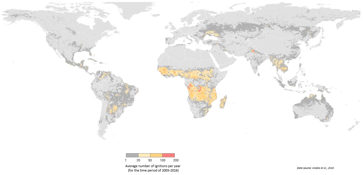
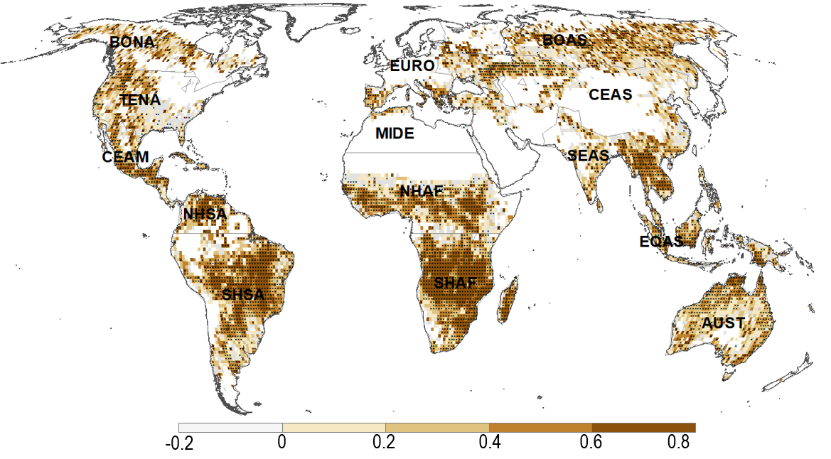
Our understanding of how the incidence of resprouting varies in different fire regimes is largely qualitative. The increasing availability of plant trait data and plot-based species cover data provides an opportunity to quantify the relationships between fire-related traits and fire properties. We investigated the quantitative relationship between fire frequency (expressed as the fire return time) and the proportion of resprouters in woody plants using plot data on species cover from Australia and Europe. We also examined the relationship between the proportion of resprouters and gross primary production (GPP) and grass cover, where GPP was assumed to reflect fuel loads and hence fire intensity, while grass cover was considered to be an indicator of the likelihood of ground fire and the speed of fire spread, using generalised linear modelling. We found that plants with the ability to resprout occur more often where fire regimes are characterised by high-frequency and high-intensity crown fires.


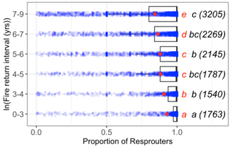
Figure 2 in Shen et al. 2023. Changes in the incidence of resprouting woody plants as a function of the fire return interval.

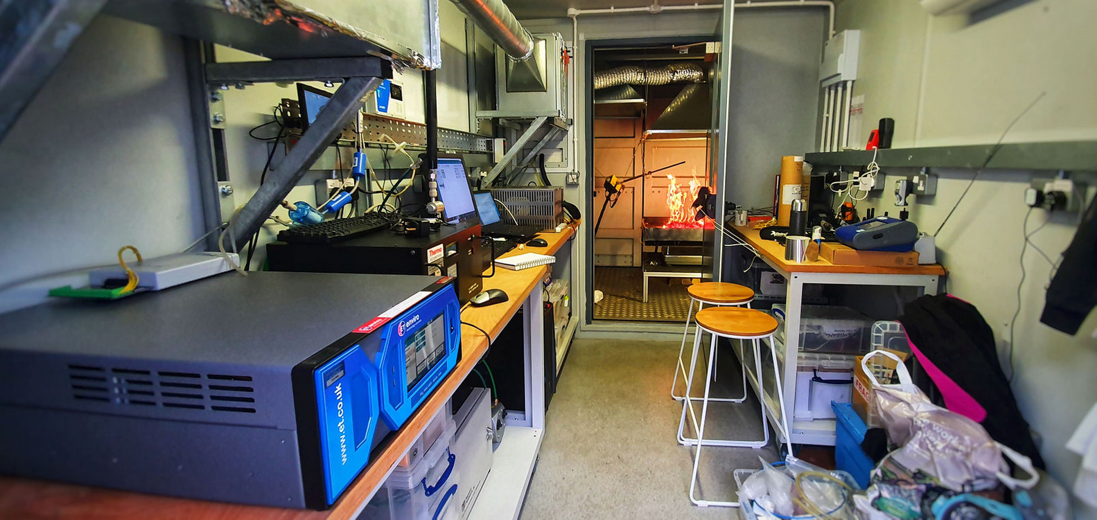
From that study, we know that resprouters are more abundant in regions with shorter fire return times, indicating that resprouting is an adaptation to frequent fires. We then want to know how quickly ecosystems recover after fire and what impact the abundance of resprouters has on recovery time because this could have a significant impact on the terrestrial carbon cycle by promoting substantial carbon sequestration. Currently, we are trying to quantify the relationship between the abundance of resprouters in an ecosystem and post-fire recovery time.

Leadership Team

This project aims to:

  • investigate atmospheric composition impacts of fire on a global scale and evaluate models’ ability to capture them.
  • quantify preindustrial to present-day radiative forcing of wildfire emissions.
  • explore impacts of short-lived fire-emitted pollutants on future climate, globally and regionally.

This project will be the first to systematically explore fire effects on atmospheric composition and climate using a wide synergy of simulations and modelling. The focus will be on short-lived species, namely aerosols and ozone precursors. Furthermore, this project aims to involve the use of targeted simulations (primarily from satellites) and a carefully selected suite of observations that will help evaluate the models’ ability to simulate atmospheric composition and the role of wildfires, in a process-based way. Model sensitivity experiments, in conjunction with the observations, will help identify the role of wildfires in past and future climates. Specifically, this project’s objectives will be on preindustrial to present-day radiative forcing of wildfire emissions, and on exploring climate feedback and impacts on future atmospheres.

Fig1. Global map showing the average number of ignitions per year for the period 2003 to 2016. The data used were derived from Andela, N., Morton, D. C., Giglio, L., & Randerson, J. T. (2019). Global fire atlas with characteristics of individual fires, 2003-2016. ORNL DAAC. Oak Ridge, Tennessee, USA. https://doi.org/10.3334/ORNLDAAC/1642


Leadership Team

The objective of this PhD project is the development and application of a fully coupled fire-composition-climate Earth system model to quantify the impacts of fire variability on atmospheric composition-climate interactions in present and future worlds.

Figure 1: Burnt area fraction  mean annual average (1997 – 2010) for a) observations (GFED4s) (left panel) and b) UKESM1+INFERNO (right panel).

The initial steps of this project have culminated in the first paper of this PhD, titled “Coupling interactive fire with atmospheric composition and climate in the UK Earth System Model,” which describes the work performed to develop and evaluate a fully coupled fire–climate–composition Earth System model replacing the prescribed transient monthly varying biomass burning emissions in UKESM1. As a result, through atmospheric chemistry and aerosols, the interactive fire emissions can affect radiation and clouds, thereby affecting weather/climate and the meteorological drives of fires themselves. This work has demonstrated that the coupled model has similar performance in reproducing the distribution of aerosols and carbon monoxide atmospheric column. This shows that including INFERNO in UKESM1 (UKESM1+INFERNO) provides a useful coupling framework that allows for an internally consistent representation of complex fire-climate-composition interactions and feedbacks in the Earth System.

Currently, this project is focused on quantify the impacts of fire variability on atmospheric composition-climate interactions using future climate scenarios.

Leadership Team

Wildfires play a fundamental role in the Earth system.  Globally, an area of the order 350 Mha is burned on an annual basis, with substantial associated carbon emissions.  The disturbance to the atmospheric and surface state caused by fire events can be sensed remotely from space using a variety of techniques, including identification of ‘hot-spots’, burnt area and fire radiative power as well as atmospheric impacts such as concentrations of certain gases and aerosols.

Termed by NASA the ‘fire continent’, substantially more than half of all global annually burned area occurs in Africa (Giglio et al., 2013).  While there has been a substantial amount of research focused on quantifying African fires and their gaseous and particulate emissions, and on investigating their interplay with cloud formation and development, work has tended to focus on specific locations within the continent and not on the overall impact of fire activity on top-of-atmosphere, atmospheric and surface radiative energy budgets at different scales.  Both temporal and spatial resolution are likely critical in correctly capturing the severity of fire events in terms of their instantaneous and longer-term radiative impacts (e.g. Andela et al., 2015, Dintwe et al., 2017).  Quantifying and understanding the drivers behind these scalings will also bring new insights as to how well the link between fire occurrence and radiative impact is, and can be expected to be, captured in current global Earth-system models.

In this project we will primarily make use of high temporal resolution observations from two instruments onboard the geostationary Meteosat series of satellites, namely the the Spinning Enhanced Visible and Infrared Imager (SEVIRI) and the Geostationary Earth Radiation Budget (GERB) instrument, both viewing Africa from 2004 until the present day.   We will use the fire detection tools developed by co-supervisor Wooster and implemented operationally on the data stream coming from SEVIRI and use these alongside data from GERB, which is the only broadband instrument in geostationary orbit, and which assesses Earth’s outgoing energy fluxes every 15 minutes.  Alongside this information we will use burned area data mapped from a series of polar-orbiting satellites, such as the European Sentinels and NASA’s Terra and Aqua. Studies using synergistic data from SEVIRI and GERB have already established techniques to probe the radiative impacts of cloud and dust aerosol, and this project represents an ideal opportunity to develop and apply these approaches and insights to the specific challenge of wildfires.

This project is half funded by Leverhulme Wildfires, and half by NCEO

Project duration: 2021-2025

Leadership Team

Wildfire represents an increasing risk to people and property. There is concern that if present trends continue, the risks to insurance and re-insurance companies will become unsustainable, and property in fire-prone regions will become uninsurable. The problem arises because historic data, on which insurance pricing generally depends, are no longer a reliable guide to wildfire risk. Palaeodata provide evidence that biomass burning, regardless of greater or lesser human intervention, is highly sensitive even to small (< 1˚C) regional temperature shifts. Severe fire seasons during the past year in southeastern Australia, California and Siberia reflect unprecedentedly high temperatures, combining with specific atmospheric circulation patterns, to create extreme fire risks.

There is thus an urgent need to develop a new approach to the spatially detailed assessment of wildfire risk in the present and the near future that takes account of the non-stationary nature of climate, together with current understanding of the meteorological, ecological and human influences on fire. The project will demonstrate the feasibility of mapping present and near-term wildfire risk using a combination of climate and wildfire models.

The project will exploit the availability of large ensembles and long runs of leading climate models, including state-of-the-art models used by the UK Met Office (Exeter) and the EC-Earth model, which is based on the European Centre for Medium-range Weather Forecasts (Reading) forecast model and used for climate prediction in several countries. Instead of focusing on long-term projections, as much of the “climate impacts” literature does, this project will focus on the present. The idea is to represent the present climate probabilistically, based on model ensembles that represent alternative realizations of the climate, all consistent with the present composition of the atmosphere. This work will also quantify climate 5-10 years into the future. This can be done with reasonable confidence because different scenarios of future carbon emissions do not produce noticeably divergent climates until 20 or more years hence.

The other key element of this research will be a global wildfire model. Current “process-based” vegetation-fire models are based on a still-limited quantitative understanding of the processes, and do not perform to the standard required. On the other hand, remotely sensed data on fire occurrence, burnt area and fire radiative power are abundant, publicly available, and improving. Empirical models can therefore be developed, relating wildfire (as seen from space) to its multiple controls. The Figure (left) shows an example based on annual burnt-area statistics on a coarse (0.5˚C) global grid. The panels are partial residual plots based on a generalized linear model.

By combining probabilistic modelling of both climate and wildfire, this project is therefore expected to achieve a substantial advance in the state of global fire modelling; while also providing a proof-of-concept for a new scientific approach to the quantification of this increasingly important risk.


Project duration: 2021-2025.

This project is also co-supervised by Prof T Shepherd (Reading) and Ioana Dima-West (AXA XL) with support from Alexander Vessey (AXA XL)

Leadership Team

Wildfires are integral part of global ecosystems. At the same time, they pose a threat for the manmade environment and constitute a major CO2 emission producer. Changes in the burned area by wildfires have been widely attributed to respective changes in climatic drivers. Understanding the connections between climate parameters and the wildfire activity has a great scientific and managerial importance. In this project we analyze observed burned area (BA) sizes on different Global Fire Emissions Database (GFED) pyrographic regions, and the respective Fire Weather Index (FWI), to identify correlations between them.

At a global scale, a rough 42% of the area that exhibit any correlation between BA and FWI, show statistical significance at 95% level. The region with the highest rate of significant positive correlation is South Africa (SHAF) with a rough 82% fraction of area exhibiting statistical significance, followed by Central and South America, and Equatorial Asia regions, with an approximate 60%. The project is currently exploring alternative techniques to correlate FWI, but also climate parameters to BA.

Figure: Pearson’s correlation coefficient between FWI and log10(burned area). Stippled regions correspond to p value < 0.05. Grid-boxes with 5 months or less of recorded burned area were not considered. FWI data from NASAs reanalysis project MERRA2[1], burned area estimates from MODIS (MCD64A1)[2]. Period of analysis, 2001-2015.

[1] https://portal.nccs.nasa.gov/datashare/GlobalFWI/v2.0/wxInput/MERRA2/

[2] Giglio L, Boschetti L, Roy DP, Humber ML, Justice CO. The Collection 6 MODIS burned area mapping algorithm and product. Remote Sens Environ. Elsevier Inc.; 2018 Nov 1;217:72–85.

Leadership Team

Controlled fire use plays an important contemporary role in sustaining human cultures and livelihoods and fire-dependent ecosystems, as well as reducing wildfire risk. This post-doctoral project involves gathering and analysing information about human fire use practices worldwide by two means.

The first is a global review of literature on fire use and mitigation practices within smallholder and subsistence-oriented livelihoods. Qualitative and quantitative information collated from these studies will be used to inform our understanding of the social and environmental drivers of change in fire use, the spatiotemporal patterns of fire set for different livelihood purposes, and the governance of human fire use. The review will also highlight data gaps to direct future case study research.

The second is a survey of experts, including fire academics and practitioners, covering reasons for burning, seasonality of burning, and fire governance, for a pre-determined set of regions of the world. The survey will be used to map fire use and point to key fire uses for different regions and biomes of the world. Survey participants will also be engaged in workshops to explore the dataset.

One envisaged outcome of the work is the development of a framework and methodology to integrate local level fire knowledge and information into larger scale models of fire dynamics. The project involves working closely with other researchers in the Centre, crossing the social and natural sciences to strengthen interdisciplinary understanding of fire, its drivers, its impacts, and its social and ecological importance.

Publications:

Smith, C., Perkins, O., & Mistry, J. (2022). Global decline in subsistence-oriented and smallholder fire use. Nature Sustainability, 5(6), 542-551.

Project duration: 2020-2026

Leadership Team

This PhD project is looking at the effects of changing tropical aerosol emissions, including from fire, on climate and human health. We use different forms of emissions experiments using a global climate model, UKESM, to understand these impacts.

First we understand the general response of the climate to changes in tropical biomass burning aerosols by studying the effect of large perturbations to their emissions – a 10 times increase, or a complete removal. This helps us to characterise the large effects of changing these emissions on local and remote temperatures, precipitation, circulation, and clouds, aiding us in an understanding of the effect of the further experiments.

The subsequent experiments apply time-varying emissions scenarios over the 21st century, from the climate change-focused Shared Socioeconomic Pathways (SSPs). We investigate the effect of Africa following SSP370 (lower mitigation) while the rest of the world follows SSP119 (high mitigation), compared to a global SSP119 control. These experiments are being used, with insights from the larger experiments, to determine the human health and climate effects of changing between these realistic 21st century emissions scenarios.

Project duration: ends 2021

Leadership Team

In recent years wildfires have made headlines in Australia, California, continental Europe and even the UK, and satellite data are the only way to robustly track and quantify the phenomena across such large scales, something that can now be done close to real-time. Two traits of particular interest are fire intensity and combustion phase (i.e. smouldering vs. flaming), which strongly influence the amount and chemical composition of smoke and in turn controls its impact on the atmosphere and on air quality. Whilst satellite data are commonly used to identify where fires are burning, there are no proven means currently of extracting these fire characteristics, and even detecting the fires requires use of manually tuned algorithms that are time-consuming to optimise.

This project will explore the use of multi and hyper-spectral laboratory and airborne remote sensing in characterising landscape fires, and ultimately the use of such metrics to help improve and validate new information extractable from satellite observations of active fires.

This project is also co-supervised by Rob Francis, KCL.


KCL combustion chamber at Rothamsted Research. Photo: Martin Wooster.


British Antarctic Survey aeroplane, fitted with KCL remote sensing equipment. Photo: Adriana Ford, Leverhulme Wildfires 2021


Leadership Team

This PhD project aims to explore global drivers of burnt area (BA) in order to improve the way BA is modelled by the INFERNO fire model. The INFERNO fire model is part of the JULES land surface model, which is itself part of the UK earth system modelling project (UKESM).

The first part of the project, which has culminated in the first paper of the PhD, titled “The importance of antecedent vegetation and drought conditions as global drivers of burnt area”, aimed to quantify the global drivers of BA. The study placed particular emphasis on the importance of antecedent vegetation variables, since previous studies have found that current fire models do not represent the relationships between antecedent vegetation and fire well.

Currently, the project is concerned with translating results from the aforementioned study into tangible improvements to the performance and reliability of the INFERNO fire model. This will involve adapting the existing simple statistical nature of the model in order to take the newly quantified relationships into account, especially the relationship with antecedent vegetation.


Read blog post here

Project duration: 2018-2022

Leadership Team

Partners