
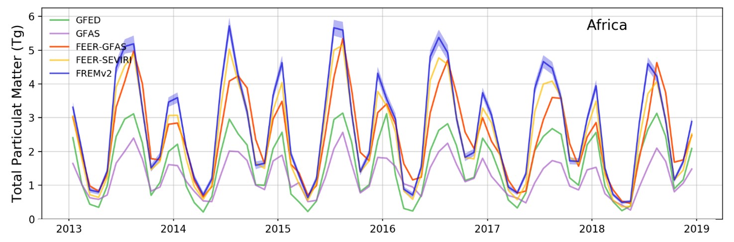
Image: Monthly emissions of total particulate matter (TPM) from landscape fires in Africa for 2013 to 2018, as derived using the updated “Fire Radiative Energy Emissions” (FREM) methodology (blue) and compared to those of other inventories: GFEDv4.1s (green), GFASv1.2 (purple), and the FEERv1.0 coefficients applied to the GFASv1.2 (red) and SEVIRI FRE data (yellow). FREM confirms the data from FEER that emissions of particulate matter appear far higher than the GFAS and GFED inventories suggest.
Even a single large landscape fire can emit huge quantities of smoke, and at the continental scale such emissions can significantly impact the composition of our global atmosphere. Smoke is a complex mix of particulate matter (PM) and gases such as carbon dioxide, carbon monoxide and methane, and the amount released by fires on Earth is so large that it significantly impacts air quality, weather and climate. Biomass burning emission inventories provide information on the composition and amount of smoke being released by landscape fires, and are thus a critical component of atmospheric chemistry and earth system models, which themselves are used for scientific studies, to inform policy decisions (e.g. related to climate change), to guide land and fire management, and provide early warning of air quality episodes. Most fire emissions inventories are driven by satellite data, but despite many advances in satellite remote sensing technologies and the ways in which the satellite data are converted into estimates of smoke emissions, many uncertainties and discrepancies remain between the various inventories on offer.
Most emissions inventories can be divided into approaches using either satellite-derived burned area or fire radiative power (FRP) measures (the latter being an estimate of how much thermal energy a fire is radiating away). Perhaps the greatest uncertainty in the former is in the amount of fuel burned per unit area, which is usually modelled or somehow otherwise estimated before being combined with the burned area measures. The main limitation of the latter approach is uncertainty associated with turning the satellite-derived FRP measures into estimates of fuel consumption, a process that relies on conversion factors derived from small-scale laboratory studies or burned area-based inventories. One possible solution to reduce uncertainty is to bypass this part of the FRP-based emissions calculation entirely, using a so-called ‘top-down’ approach that relies on satellite measurements of the atmosphere to provide the conversion factor. In this way the Fire Radiative Energy Emissions (FREM) approach generates smoke emissions estimates directly from satellite observations of FRP, linking this to emissions of particulate matter (and trace gases) through other satellite observations of smoke plume aerosol optical depth (AOD).
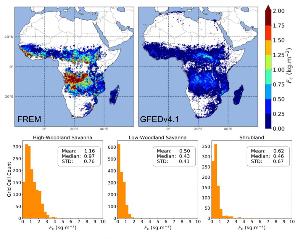
A new study published in Remote Sensing of Environment by members of the Earth Observation and Wildfire Research Group, Centre for Cross-disciplinary Approaches to Non-Equilibrium Systems, The National Centre for Earth Observation at King’s College London, and the Leverhulme Centre for Wildfires, Environment and Society – all based at King’s College London – has advanced the FREM methodology further, evolving the approach to be more accurate and developing the highest spatio-temporal resolution African landscape fire emissions inventory currently available. The technique enables the relatively high spatial resolution mapping of fuel consumption per unit area to be achieved across Africa for the first time from satellite data alone (Figure 1).
The technique enables the relatively high spatial resolution mapping of fuel consumption per unit area to be achieved across Africa for the first time from satellite data alone
Hannah Nguyen, PhD student at King’s College London and lead author of the study, explained the improvements they made to FREM – “By exploiting AOD observations that are 10 times higher spatial resolution than those previously used we have been able to more accurately match the energy released by individual fires to the mass of particulate matter they emit through combustion. In addition, the MAIAC (Multi-Angle Implementation of Atmospheric Correction) AOD data used in this study show improved performance over thick smoke close to fire sources, which is often masked as clouds in other AOD products, the data are also less impacted by the view angle between the satellite and the Earth’s surface. Several other advancements, such as the use of Landsat Tree cover observations in biome classification, and the inclusion of relatively small fires in emissions estimation have also been introduced in this updated methodology.”
Prof. Martin Wooster, Associate Director of the Leverhulme Centre for Wildfires, Environment and Society, and co-author of the study, added, “Being able to remove some of the assumptions and reliances inherent in most existing fire emissions inventories is an important step – and we were pleasantly surprised to see how well our emissions estimates were made with this updated technique, in many ways agreeing with existing inventories that use different data and assumptions. However, we also see disagreements – and in many areas our emissions estimates, and also our fuel consumption per unit area measures, are higher than most other inventories. We need now to work on confirming these new patterns, which if correct meant that African biomass burning is a larger source of smoke emissions to the atmosphere than even currently assumed.”
The FREM approach will now form the basis of a new operational fire emissions product to be delivered by the EUMETSAT Land Surface Analysis Satellite Application Facility, and will also be extended to improve historic smoke emissions estimates back to 2004 using the full Meteosat SEVIRI FRP archive. The method is being applied to other geostationary satellites spanning the globe in order to extend the inventory beyond Africa.
Contact: Dr Adriana Ford, Centre Manager, Leverhulme Centre for Wildfires, Environment and Society, wildfire@imperial.ac.uk
